In this blog Sebastian Gutierrez and Sarem Norouzi from the Department for Agroecology at Aarhus University discuss how soil spectroscopy can be used to create more accurate, scalable soil health maps for Denmark and beyond.
Why soil spectroscopy matters
Soil spectroscopy is a fast and low-cost way to measure important soil properties such as organic carbon, texture, and chemical composition. When combined with conventional laboratory analyses, spectroscopy helps build a clearer picture of soil health by increasing the amount of information available while reducing analytical costs and the need for large numbers of physical soil samples.
However, spectral datasets can be complex. Each soil sample contains hundreds or even thousands of data points, many of which are repetitive or add little value. Working with such high-dimensional data can slow down modelling and sometimes reduce accuracy. To address this, we use dimensionality-reduction techniques that condense these large datasets into compact ‘latent variables’ (or compressed factors that capture the important patterns) that retain the most useful information.
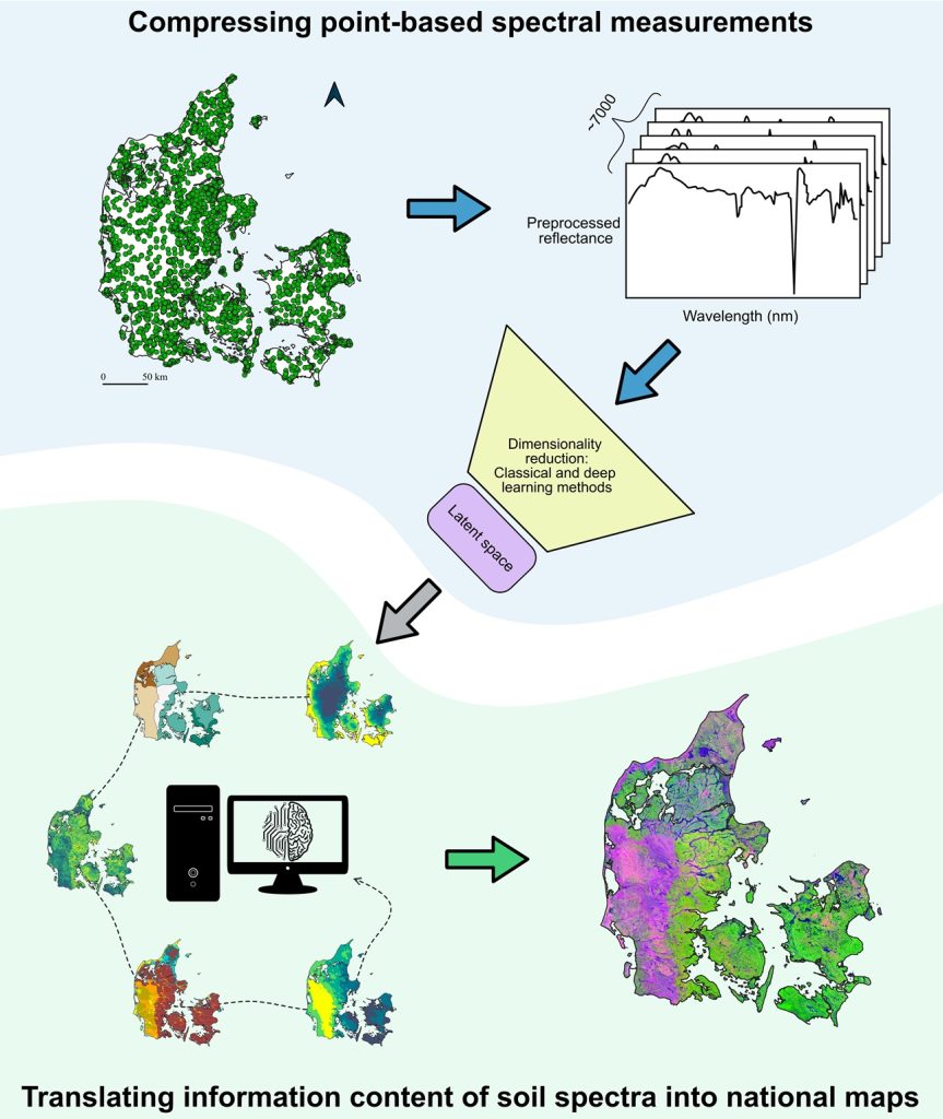
Figure 1 provides an overview of this process, showing how visible and near‑infrared spectral data (Vis–NIR) from Denmark were compressed into latent variables and then translated into spatial layers to support future national-scale soil health assessments. Graphic courtesy of Anne-Cathrine Storgaard Danielsen.
Compressing point-based spectral measurements
We compared traditional statistical techniques with modern deep-learning methods to reduce Vis–NIR topsoil spectra collected across Denmark between 2018 and 2023, covering agricultural land, forests, grasslands, and wetlands. Newer nonlinear and deep-learning approaches allow us to capture more complex patterns in the spectral data and better reflect the processes that shape soil properties.
These compressed latent variables reduce redundancy while preserving the most important spectral features. Our findings show that more advanced analytical methods like non linear methods are particularly effective at keeping the essential information needed for accurate soil modelling, making them more reliable for supporting large-scale soil monitoring and mapping.
Translating soil spectral information into national maps
We mapped the compressed spectral information using climate data, terrain attributes, and parent-material maps as environmental predictors. Across all methods, climate and parent material consistently emerged as key drivers. Parent material affects the mineral composition of soils, while climate and terrain—especially factors related to water movement—shape soil-forming processes that influence spectral signatures.
The resulting maps are powerful because they capture nonlinear relationships between soils and their environment. They offer a coherent, spatially rich representation of soil variation that complements both traditional soil surveys and remote-sensing products. National patterns reflect Denmark’s glacial history, while local variations align with well-known landscape features.
For example, soils in western Jutland are strongly influenced by coarse materials such as glaciofluvial sands and sandy tills from the Saalian glaciation. Further differentiation across western and northern Jutland reflects coastal aeolian sands, marine deposits from the main Weichselian ice advance around 22,000 years ago, and post-glacial marine sediments in northern Jutland.
Contributing to soil health programmes
Because soil spectra reliably reflect chemical, physical, and hydrological properties, the latent-variable layers developed in this study can support national-scale prediction of soil properties and consistent soil classification. This is directly relevant to policy initiatives such as the EU Soil Monitoring and Resilience Law, which calls for harmonised, indicator-based soil health assessments across member states.
Beyond physical and chemical attributes, the spatial patterns captured in these layers can support soil biology research and help guide more targeted and sustainable soil-management practices. Together, they provide a flexible, data-rich foundation for advancing soil health assessment, land-use planning, and natural-resource management in Denmark.
By offering accurate, spatially explicit information and robust analytical tools, this work helps land managers and policymakers make informed, long-term decisions that strengthen agricultural sustainability and soil resilience.
Why this matters for farmers and land managers
Ultimately, by providing more accurate and affordable soil information, the spectral-based layers developed here make it easier to understand where soils are thriving and where they are under pressure. This could help farmers and land managers target actions such as improving organic matter, reducing erosion risk, or adapting practices to local soil constraints. It also strengthens the evidence base for agri-environment schemes and emerging soil-health requirements, while offering a reliable way to track how soils change over time. In short, these tools give land managers clearer insights and greater confidence in making long-term, sustainable decisions for their land.