Data from the LUCAS soil database has revealed a critical warning: 60-70% of Europe’s soil is now classified as unhealthy. But what exactly is LUCAS soil, and how does it gather this essential data?
Here, Aarhus University researcher Lucas de Carvalho Gomes explains how LUCAS soil works and how its powerful insights are supporting EU policy.
What is LUCAS soil?
LUCAS, or the Land Use/Cover Area frame statistical Survey, is a regular survey approved by the European parliament. Using about 400,000 sample points throughout the EU, it estimates the area occupied by different land use or land cover types (d’Andrimont et al., 2024). In 2009, the European Commission extended LUCAS to sample and analyse the main properties of topsoil in the EU, a survey known as LUCAS Soil (Orgiazzi et al., 2018). This extension aims to build a consistent, expandable and harmonised database of soil properties across the EU. Soil samples are collected based on standard sampling and analytical procedures, with all analysis taking place in a single laboratory to ensure consistency.
When the first LUCAS soil sampling took place in 2009, approximately 20,000 soil samples were collected around the EU, with a focus on the main soil properties (e.g., soil texture, soil organic carbon). The survey was repeated in 2015, 2018 and 2022, each time with an increased number of samples and expanded analysis. In 2018 and 2022, new properties such as soil biodiversity were analysed for the first time. By 2022, the survey had grown significantly, with initial plan to cover about 40,000 samples across the EU.
How the LUCAS Soil Sampling Campaign Works
The LUCAS soil survey collects data from selected points across EU countries, chosen according to categories from the CORINE Land Cover dataset (e.g., cropland, grassland, forests, wetland, etc).
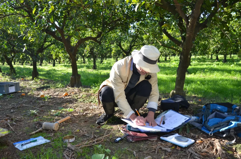
In each selected sampling point, soil samples are taken using a specific method. Five small soil samples are taken from the top 20 cm of soil at each location – at the central location, plus four points around it to the north, east, south, and west. These samples are then combined to make one larger sample (Fig. 1). About 500 grams of each soil sample is dried and sent to the lab. Additional sub samples (fresh samples) are also collected and stored in cooler conditions to assess soil biodiversity using DNA analysis. Undisturbed soil samples are taken separately for bulk density. Other data on vegetation and land management (like ploughing or grazing) are also recorded, allowing researchers to monitor how land use/management affects soil health over time.
LUCAS provides critical data on key soil parameters such as:
- Soil organic carbon: Essential for carbon sequestration and fertility
- Soil pH: Important for plant growth and soil organisms development.
- Nutrient content: Including nitrogen, phosphorus, and potassium levels.
- Soil texture: Referring to the proportion of sand, silt, and clay in the soil.
- Contaminants: Monitoring for pollutants such as heavy metals.
Most of these parameters are considered as soil health descriptors in the Proposal for the Soil Monitoring Law or are essential for building other soil health descriptors.

LUCAS Soil: Supporting EU Policies and Research
The LUCAS soil database is freely available after prior registration, and so has become a critical resource for researchers, policymakers, and environmental organisations in the EU. LUCAS data has been used in scientific research to better understand soil carbon sequestration, soil degradation, and the impacts of land use change on soil health across the EU. In the last decade, machine learning has been used to combine the soil sample data with maps of environmental variables (e.g., temperature, precipitation, altitude) to create soil property maps for the whole of Europe. These maps are also open source, and have formed the basis for spatial analysis of soil degradation in the EU.
LUCAS Soil’s sample information and output maps also support several EU policies, including:
- The Common Agricultural Policy (CAP): LUCAS data helps inform decisions on agricultural subsidies, land management practices, and rural development programs.
- The European Green Deal: Soil health is integral to achieving the EU’s ambitious climate and biodiversity goals, including carbon neutrality by 2050.
- The EU Soil Strategy: LUCAS data underpins efforts to protect soils, prevent erosion, and improve soil management across member states.
Challenges and future directions
While LUCAS has significantly advanced soil monitoring across Europe, challenges remain, including harmonization of existing soil data across the EU. The proposed Soil Monitoring Law suggests that each EU member state should establish its own soil monitoring system, with LUCAS sampling providing a portion of the required samples. To achieve this, countries without established national monitoring systems could receive additional support. Using LUCAS’s standardised methodology, national surveys could greatly increase the number of harmonised soil samples collected across the EU.
Soil biodiversity is crucial for soil health, but our knowledge of it across the EU is still limited. While LUCAS collected soil biodiversity samples in 2018 and 2022, more sampling is needed to cover additional locations. The proposed Soil Monitoring Law should also require a standardised methodology for soil biodiversity (the same one used by LUCAS) to be implemented by Member States. This approach would produce harmonised soil biodiversity data, which could then be easily combined with LUCAS data.
Looking ahead, there is interest in incorporating advanced technologies into the LUCAS campaign, such as sensor fusion and AI tools for field use. These technologies could improve soil monitoring by reducing costs and speeding up data analysis and distribution. As we work toward achieving healthy soils by 2050, the LUCAS soil database’s temporal data can help identify areas already showing signs of soil degradation, such as loss of soil organic carbon, where mitigation measures can be applied.
Conclusion
The LUCAS soil sampling campaign represents a crucial effort to protect Europe’s soils for future generations. By providing standardised, comprehensive data on soil health, LUCAS supports both scientific research and EU policies focused on soil conservation. In AI4SoilHealth, we are using soil samples from LUCAS and other sources, combined with AI technologies, to better understand soil health trends across the EU. As Europe confronts challenges like climate change, land degradation, and food insecurity, LUCAS soil will continue to be a key resource for supporting sustainable land management strategies.